Saturday, October 31, 2009

The Magnificent Monolith


October 28


More flat red earth, dotted with desert oaks and spinifex to drive through. Every kilometre was different and every one was worth stopping to admire. The colours were dazzling.


We paid our entry into the National Park, booked into the one and only caravan park and set off to see the Olgas, now more often called Kata Tjuta. These massive chunks are conglomerate, unlike Uluru which is a particular form of ancient granite called arkose. We stopped first at a viewing area looking across towards the jumble of rocks, through groves of desert oaks. Except for these designated viewing spots, there's no opportunity to pull off the road and there are signs specifically forbidding this just in case you might try.


I liked the way that the grid to protect the dunes you cross on foot was painted to match the landscape.


And the pattern made by wind pushing sand up against the grid.


A crested pigeon eyed me hopefully as I took the obligatory photos.


Further on, we followed a short track that led into one of the gorges between the rocks.


There was still a trickle of water across the track at one point in spite of months of drought.


The curves of the rock are so voluptuous, we were not surprised to read that this was a place in aboriginal lore for "secret men's business"


Returning the 40 or so kms to Uluru, we followed the road around its base. Photos cannot capture how vast this monolith is as it towers above the plain. Naturally that doesn't stop any of us, including me, from taking our own snapshots, which look like everyone's else's snapshots, and not as good as those of the professionals.


If this was a Facebook page rather than a blog I would here insert a picture of me jumping in the air in front of Uluru. Instead I focused on some birds (kingfishers?) near a waterhole,


a lone climber (most people respect the traditional owners' request that you not climb the rock),


and some of the curves and folds in the huge monolith.


The moon and a cork tree against the flank of the rock also appealed to me.


Along with many others we returned at dusk to watch the changing colour as the sun went down.


Friday, October 30, 2009

The Road to Uluru

October 27

We had a long drive to reach Curtin Springs Station, our destination for the night, just outside the huge National Park that surrounds Uluru.

We drove under dazzling blue sky, through flat land stretching away in all directions, sometimes coated with bleached yellow grasses, sometimes dotted with fan-shaped mulga trees. From time to time we saw the columnar shapes of desert oaks, like an outback version of Mediterranean cypresses. The earth varied between deep, rich terracotta, screaming orange, and pale salmon pink. After a while you simply stopped taking photographs and tried to absorb it all.


Just before the right turn onto the Lasseter Highway to head directly west, we passed Stuarts Well, and were tempted to check out the dingo.


Another time, maybe.

There was the usual kangaroo roadkill on the verges, and at one point we came upon some wedge-tailed eagles gorging themselves. They moved away a little, but only one bothered to take flight as we passed. Ho-hum, just another bunch of tourists!


Curtin Springs was about as stark a little roadhouse as any we'd come to so far. Unpowered sites were free, and also offered a minuscule amount of shade.


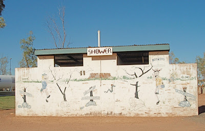
The toilet block was corrugated metal, spelling and grammar optional.


Showers were $2.50.


Just as shabby - maybe even more so - as the roadhouse at Ti-Tree, this one also had its annoying resident bird. Here it was an emu


that had pretensions to being an art critic.

Back to Alice Springs


October 26


In the morning we walked down to the gorge again, which looked quite different although just as beautiful in the strong sunlight.


Heading back towards Alice Springs, we stopped at Ormiston Gorge, now much less crowded, and enjoyed its towering cliffs and deep pools of water.


With so few people around, a trio of herons had also arrived on the sandbar along one edge.


They took off as another couple of visitors arrived on their strip of beach.


Another stop we had skipped on the way out was at the Ochre Pits, a place where aborigines have for years gouged the colourful clay out of the banks along the dry river bed, using it mainly for body paint. The steep banks were striped like rainbows in subtle hues of ochre, sienna, creamy white and lavender.


Only male aborigines are allowed to collect the clay; there's a fine of $5,000 for anyone else caught helping themselves.

The day was cooler than the previous four or five, which made everything more pleasant. We got back to Alice Springs, planning to stay again at the caravan park we'd been at before, but as we arrived about 5 cars full of noisy schoolchildren, obviously on some kind of field trip, were pulling in. We beat a retreat to the G'day Mate Caravan Park just around the corner, not as well-groomed but green and leafy nonetheless,


and full of cheerful, mostly Aussie, types, a welcome change from all the severe Germans and Dutch in the first park. The couple across from us informed us proudly that they were grey nomads, having sold up everything in Terrigal where they had lived for 30 years. (Terrigal is one of the ugly coastal towns north of Sydney, with glaring red-brick villas and strip malls. No wonder they were enjoying the rest of Australia!) They had been at the G'Day Mate Park for 5 weeks. In the back window of their van was this sign.


Not long after we arrived, the woman received a customer. She set up a little stool in the shade and gave her henna-haired client a short-back-and-sides with electric clippers. I was tempted to get a trim, just for the photo-op, but ran out of time. (Too busy updating this blog.)

Getting to this caravan park involved crossing the Todd River.


We were a month too late for the annual Henley-on-Todd regatta. There are classes for rowing fours and eights, sailing boats and dinghies. The crews hold up the bottomless hulls and run down the river bed.

Monday, October 26, 2009

West MacDonnell Ranges

October 25

Sunday ... but we skipped the pancake breakfast. I went over there to wash our dishes in the communal sink, and saw various couples and families arriving with plates and mugs in hand. A man was handing out name-tags: "Just your first name and where you're from." It had the air of a bible camp, and I escaped before anyone could start up a chorus of Amazing Grace.

We set out westwards, travelling through more of the amazing desert landscape we were getting used to.


Our first stop was Simpsons Gap, and here the contrast with the East MacDonnell range became apparent because, in spite of the long drought, there is still water in the canyons on this side.


While Michael painted, I tried to capture, yet again, the flocks of zebra finches in the trees. They are the tiny yellow dots among the branches. There was a hawk that dived on them from time to time: as it swooped, the little birds would take off in a wave. The whirring of all those tiny wings made a sound like a rolling wave too.


Next was Standley Chasm, famous for the sheer vertical walls so close together. We would have been more impressed if we hadn't visited an even steeper, narrower chasm in the Blue Mountains some months back. Of course, the Blue Mountains rocks didn't have the brilliant colour.


Standley Chasm, though on private land and charging $8 a head to visit, is popular with tour groups, so we encountered a lot more people here than at other spots. The path to the chasm had a wonderful assortment of cycads growing among the eucalyptus, something we saw only in this particular location.


We skipped a couple of other waterholes, including Ormiston Gorge on the way out, daunted by the number of Sunday funseekers arriving with their picnic supplies and swimming gear.

At the end of the sealed road we secured a place in the grandly-named Glen Helen Resort, which was a pretty sparsely landscaped stretch of ground with a series of permanent tents reserved for people on adventure tours, a couple of metal shed-like structures for shower and toilets, and a tavern. South of the whole set-up loomed high red cliffs reflecting the warmth of the day back at us in both colour and temperature.


It had been another really hot day and we were feeling tired. "You should go for a swim in the gorge," advised the local ranger as he passed by at dusk. "It's lovely now all the kids have gone". So off we went on the ten-minute walk down to the gorge. The ranger was right. It was lovely - and deserted except for ourselves and a few birds.


The water was deep, cool and very refreshing.

Later that evening we went down to the tavern and joined other campers listening to live music in the bar room from a grizzled guy with guitar, a kind of banjo/mandolin and a fiddle, singing bluesy Leonard Cohen, Leon Redbone and Bob Dylan. At one point he also demonstrated his prowess with the spoons evoking our memories of a visit to Prince Edward Island about a decade ago.

Alice Springs (continued)

October 24

This was our day to really have a look around The Alice.


The shops were less interesting than they had appeared at first glance. The botanical garden was again a bit of a disappointment although they did seem to have made an effort with display boards giving useful information about ethnobotanical plants, and local birds, frogs, animals. One of the best things about it is its name: Olive Pink Botanical Garden. Of course, it's named for a benefactor, but what a great name, considering the colours of many of the desert plants.

We also visited the Pioneer Women's Hall of Fame, but they were about to close early for lack of volunteers, so we only got a very brief glimpse of both the old jail in which it is housed, and the displays about the remarkable women of the outback. Perhaps we will have another go at visiting when we return to Alice Springs.

East MacDonnell Ranges

October 23

East out of Alice Springs, the earth is terracotta orange, contrasting with the blue-grey of the mulga. Rough, chunky hills rise out a smooth, sandy plain.


We came first to pretty Emily Gap.


A little further along was even more lovely Jessie Gap, its car park shaded by a beautiful specimen of river red gum (Eucalyptus camaldulensis).


It was a good sign. Younger trees in flower lined our path,


and several more graceful gums grew in the dry river bed.


This narrowed between steep, red walls, then opened out again into pale sand and grass. It was spectacular and we had it for the most part to ourselves.


Michael sat under a gum tree to do some painting, but had trouble keeping his paper wet in the hot breeze.


Further along the route, we came to Corroboree Rock, a dark, rugged jumble above the plain. According to our literature, it was not used for any corroborees.


We ventured as far as Ross River Homestead, hoping to find a lunch spot there, but the reception was not hospitable once it became clear that we didn't plan to stay in one of their cabins, buy a meal or booze.

Returning to town, we had a look at the aviation museum we had passed up earlier, housed in an old hangar.


Outside is one of the planes used for the Flying Doctor Service, now superseded by more modern aircraft.


Inside were more planes and associated, engines, radios, etc, including a DC3 that you could board, set up as it was for passenger flights in the days before the modest Queensland and Northern Territory Air Service became the international giant still known by those initials - Qantas.